


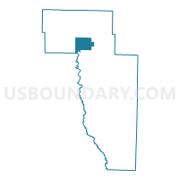
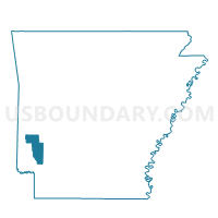
BURG Voting District, Howard County, Arkansas
About
Outline

Summary
| Unique Area Identifier | 526646 |
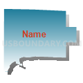
| Name | BURG Voting District |
| County | Howard County |
| State | Arkansas |
| Area (square miles) | 13.43 |
| Land Area (square miles) | 13.34 |
| Water Area (square miles) | 0.08 |
| % of Land Area | 99.37 |
| % of Water Area | 0.63 |
| Latitude of the Internal Point | 34.22132830 |
| Longtitude of the Internal Point | -94.05751770 |
Maps

Graphs
Select a template below for downloading or customizing gragh for BURG Voting District, Howard County, Arkansas


Neighbors
Neighoring Voting District (by Name) Neighboring Voting District on the Map
- BLUE RIDGE Voting District, Howard County, AR
- CLAY Voting District, Howard County, AR
- Jefferson Voting District, Sevier County, AR
- UMPIRE Voting District, Howard County, AR
Top 10 Neighboring County Subdivision (by Population) Neighboring County Subdivision on the Map
- Umpire township, Howard County, AR (251)
- Blue Ridge township, Howard County, AR (193)
- Clay township, Howard County, AR (155)
- Jefferson township, Sevier County, AR (141)
- Burg township, Howard County, AR (61)